The climate is essentially determined by the amount of radiant energy that reaches the surface of Earth from the Sun. The spatial distribution of this radiation is effected by the geographic latitude and the absorption properties of the atmosphere, including the amount of cloud cover. In Hungary, due to the small difference in latitude within the country, cloud cover plays a decisive role.
Global radiation refers to the sum of direct radiation coming from the Sun and scattered radiation from all parts of the sky.

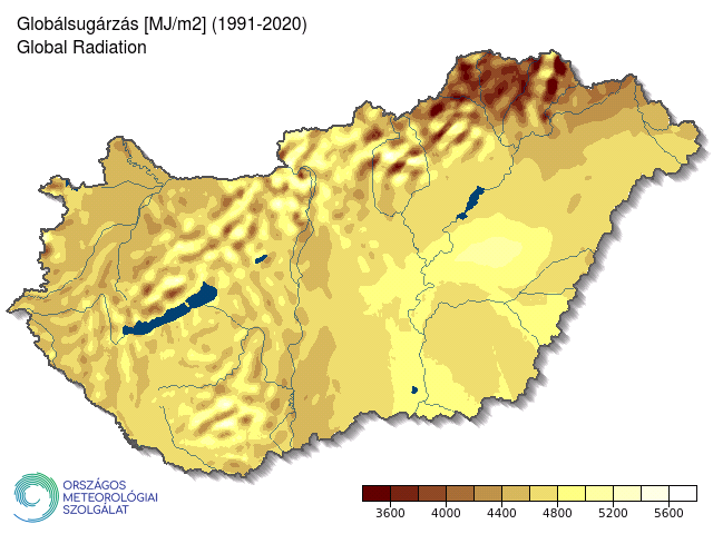
Figure 1
The average annual global radiation (MJ/m2) in Hungary (based on the 2001–2020 period)
The highest radiation values are observed in the central and southern parts of the Great Plain, particularly in the middle and southern regions of the Tisza River (Figure 1). In these regions, the global radiation ranges from 4800 to 5000 MJ/m2, exceeding 4600 MJ/m2 over extensive areas. Conversely, mountainous areas show lower radiation values due to the greater horizon limitations induced by the terrain, and some areas of the Northern Mountains can be depicted with values below 4000 MJ/m2. The western part of the country also represents lower radiation values, attributed to topographic conditions and more cloud cover associated with higher precipitation amounts compared to the countrywide average. In this area, the annual global radiation typically ranges from 4200 to 4400 MJ/m2.

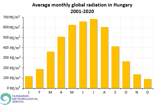
Figure 2
Monthly mean global radiation in Hungary (based on the 2001-2020 period)
Most of the radiation arrives in July, although the days are slightly shorter than in June, and the altitude of the sun is lower. However, the amount of cloud cover is less than at the beginning of summer (Figure 2). The highest degree of cloudiness and the shortest days of the year happen in December, therefore the least amount of global radiation can be related to this month.

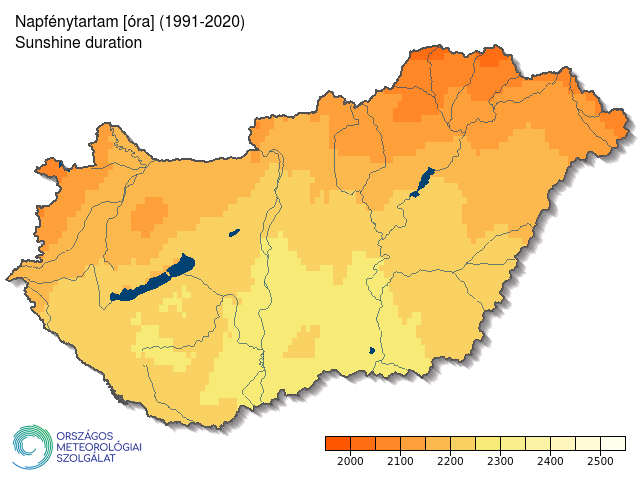
Figure 3
Annual amount of sunshine duration [hours] in Hungary (based on satellite data from 1991-2020)
Sunshine duration refers to the period during which direct radiation reaches the surface. Factors influencing sunshine duration include astronomically possible sunshine duration, topography, and cloud cover - the latter has an even greater impact on sunshine than radiation.
The Hungarian Meteorological Service stopped the conventional measurements of surface sunshine duration on April 8, 2013 in most of the stations, therefore the areal distribution of the sunshine duration is presented from satellite measurements. The Interim Climate Data Record (ICDR) sunshine duration product published within the framework of the EUMETSAT Satellite Application Facility on Climate Monitoring (CM SAF), which is based on the SARAH (Surface Solar Radiation Data Set – Heliosat – Edition 2 (DOI: 10.5676/EUM_SAF_CM/SARAH/V002) methodology. The spatial resolution of the raster data is 0.05° × 0.05°.
Based on satellite data from 1991 to 2020, the countrywide average sunshine duration per year is 2115 hours in Hungary. The sunniest areas, with over 2280 hours of sunshine per year, can be found in the southern part of the Great Hungarian Plain, while the least sunny areas, with less than 2040 hours of sunshine per year, appear in mountainous regions and the foothills of the Alps (Figure 3).
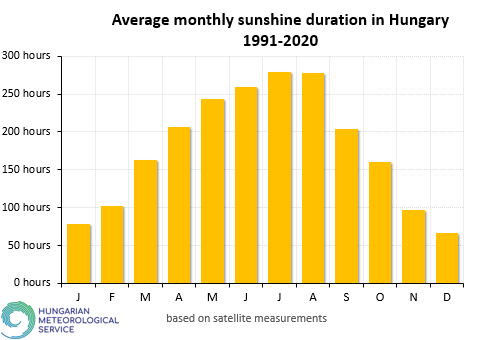
In winter, the highest mountains receive one and a half times as much sunlight as the plains, due to the inversion which is a frequent phenomenon during winter, when the mountains rise above the fog covering the lower regions. However, in summer the mountains get 10 percent less sunshine as the lower regions, because of the more cloudy and wet weather. The monthly amount of the sunshine duration is between 60 and 280 hours in average (Fig. 4). The longest days are in June, however the maximum amount of sunshine is in July. In Hungary, the period from November to January has the least amount of sunlight, especially in December.

Figure 4
Monthly amount of sunshine duration in Hungary (based on satellite data from 1991-2020)


